Visitor V 5156965
REMOTE_ADDR=216.73.216.177
SERVER_NAME=services.dwr.virginia.gov
Virginia
Department of Wildlife Resources
Virginia Fish and Wildlife Information Service (VaFWIS)
Combined Help Document for Visitor Access Privilege
Each Virginia Fish and Wildlife Information Service web page offers a "Help" link
to pop-up additional information relating to the context of the parrent page.
This Combined Help Document is created by appending all these individual help pages.
^
Help for the Virginia Fish and Wildlife Information Service (VaFWIS)
Virginia Department of Wildlife Resources
Help for the Virginia Fish and Wildlife Information Service (VaFWIS)
Available as a World Wide Web Service at https://services.dwr.virginia.gov/fwis
The Virginia Fish and Wildlife Information Service (VaFWIS) web site data is maintained by the
Commonwealth of Virginia
Department of Wildlife Resources (VDWR).
The web site purpose is to provide reports and analysis concerning fish and wildlife information resources
used by VDWR agency biologists.
VaFWIS is based on observations of fish and wildlife along with literature for all native and naturalized species found in Virginia.
Reviews performed by Department of Wildlife Resources biologists
are summarized and indexed in an agency database called Biota of Virginia (BOVA).
You will find species characteristics, habitat groupings, locations of occurrence, and management practices
described within BOVA.
Initial support for developing BOVA was provided by the Office of Surface Mining,
the Bureau of Land Management, and Virginia Polytechnic Institute and State University
Department of Fisheries and Wildlife.
Development of BOVA followed "A Procedure for Describing Fish and Wildlife"
developed with the U.S. Fish and Wildlife Service's Eastern Energy and Land Use Team.
Registered subscribers have access to additional analysis used for scientific
research, land management, permit review, and other regulatory
review of projects.
There is no charge to government agencies, non-profit organizations or public school systems.
For other entities, there may be an annual fee.
You may view the registration form
VaFWIS_Use_and_Access_Agreement.html
"How To" documents can be found using "help" links located on most pages.
Appendix
- The appendix to the visitor's user manual.
Download the appendix ".pdf" document containing database descriptions and field definitions
associated with the Virginia Fish and Wildlife Information Service.
All VaFWIS Help Pages Combined
-- The current VaFWIS Manual for
Visitor
Access Privilege
is one extensive web page constructed by appending each individual help page.
[ VaFWIS_Help December 2012 ]
^
Introduction to the Fish and Wildlife Information Service
Virginia Department of Wildlife Resources
Introduction to the Fish and Wildlife Information Service
for
Unregistered
Subscribers
May 2015
Contents
Introduction
Accessing the Virginia Fish and Wildlife Information Service
Logging into VaFWIS
The Disclaimer
A.
Introduction
The Virginia Department of Wildlife Resources (VDWR) Bureau of Wildlife Resources is pleased to provide
access to the Virginia Fish and Wildlife Information Service ("VaFWIS") via the Internet.
VaFWIS will provide you with the capability
of accessing the biological databases maintained by or available
to the Fish and Wildlife Information Services (FWIS) Section
of the Statewide Resources Division including
lists of species with
links to additional record data and maps are provided in a report.
You are encouraged to provide comments on any
aspect of this service.
Registered subscribers have access to data used for
scientific research, land management, permit review, and other
regulatory review of projects.
There is no charge to government agencies, non-profit organizations or public school systems.
For other entities, there may be an annual fee.
If you wish to learn more about becoming a registered subscriber, please contact by
email vafwis_support@dwr.virginia.gov.
Databases
currently available to
Unregistered
VaFWIS subscribers are as follows:
Anadromous Fish
Use Areas
- This dataset identifies stream reaches that are
confirmed or potential migration pathways, spawning grounds, or nursery areas
for anadromous fish.
The species included in this assessment are alewife (Alosa pseudoharengus),
blueback herring (Alosa aestivalis), American shad (Alosa sapidissima),
hickory shad (Alosa mediocris), striped bass (Morone saxatilis),
and some populations of yellow perch (Perca flavescens).
Data associated with each reach include stream name, reach length,
species confirmed in the reach, watershed, and upstream boundary.
Upstream boundaries were established at impediments
or where habitat became unsuitable.
Bald Eagle Concentration Areas and Roosts (BECAR)
- Areas identified as important to Bald Eagles.
This data is compiled and maintained by Department of Wildlife Resources biologists.
Bald Eagle Nests (BEANEST)
- Nest sites of Bald Eagles.
This data is compiled through cooperation between Department of Wildlife Resources biologists
and Center for Conservation Biology.
Biota of Virginia (BOVA)
- Virginia-specific information system begun in 1981 as a cooperative research
project between VDWR and Virginia Polytechnic Institute and State University
(VPI&SU) that contains a variety of information on over 2300 faunal species.
Breeding Bird Atlas (BBA)
- a 5-year cooperative project between VDWR and the Virginia Society of
Ornithology (VSO) that evaluated the status and distribution of breeding birds in the Commonwealth.
Impediments
- This database contains information on the impediments to anadromous fish passage
in the Atlantic Slope drainages in Virginia
(Potomac, Rappahannock, James, York, and Chowan).
Data were gathered from a variety of sources including this agency,
USEPA, and Virginia Commonwealth University.
Each impediment has several descriptive fields including impediment name,
the name of the impeded stream, dam height, purpose of the dam, date
constructed, etc.
Managed Trout Streams
- contains biological, habitat and physicochemical data about each classified trout stream reach
or specific collection location.
Originally developed in 1981 by Department of Wildlife Resources staff
in cooperation with VPI&SU,
data collection has been ongoing since 1976.
Coldwater streams have been assessed as either wild (classes I to IV) or stocked (classes V and VI)
Public Land Holdings
- This dataset identifies land owned by Federal, State, or local government.
Threatened and Endangered Species Waters (T&E Waters)
- This dataset identifies streams and rivers that contain documented occurrences
of federal/state- or state-listed threatened or endangered species and their associated habitat.
Each reach contains descriptive fields including stream name, upstream and downstream boundaries,
status (“federal/state” or “state”), and length.
Data found within the various system components
have been collected and compiled by numerous researchers, collectors, contractors and staff
in and outside of Virginia.
Their contributions to the knowledge base about the fauna of the Commonwealth are greatly appreciated.
The Virginia Department of Wildlife Resources
would like to acknowledge several agencies instrumental in the development of this Service.
Specifically,
financial support was provided in part by the U.S. Army Corps of Engineers' Norfolk District Office (Planning).
Disclaimer: The
Virginia Department of Wildlife Resources
is not responsible for the use and interpretation of these data outside of the agency.
While the Department strives to ensure that the data are as accurate as possible, errors can occur.
The Department does not warrant the data as suitable for the use to which it is being acquired.
Any questions concerning the use and interpretation of data should be directed to
vafwis_support@dwr.virginia.gov .
Note: You cannot edit data in this system.
If you identify data errors, please notify by email at
vafwis_support@dwr.virginia.gov
The issue will be researched and handled accordingly.
Additional comments or information may be directed to:
FWIS Coordinator
Virginia Department of Wildlife Resources
P.O. Box 90778
Henrico, VA 23228-0778
(804) 367-1000
The VDWR/FWIS
On-line Service Help Desk telephone number
is:(804) 367-2211.The
Help Desk is staffed between 9:00 a.m. and 5:00 p.m.
B. Accessing the Virginia Fish and Wildlife Information Service
Two steps; first from the VDWR's Wildlife Information and Environmental Services web page
at dwr.virginia.gov/wies/.
And then second, click on the link to
“Virginia Fish & Wildlife Information Service (VAFWIS)”.
C. Logging In to VaFWIS
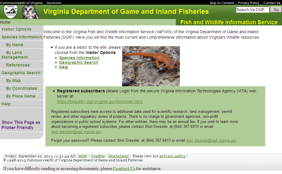
This is the "Home Page" for visitors to the
Virginia Fish and Wildlife Service. Without logging in (unregistered
users), visitors may get lists of species using either "Species
Information" of "Geographic Search" menu items. From each species in a
list you can link to scientific information gathered using library
literature reviews and research observations.
D. The Disclaimer
At the bottom of each page is a link to the Disclaimer.
Each user needs to be familiar with the terms of the disclaimer
which the user accepts when he or she uses the Service.
Disclaimer of Liability
Neither the Virginia Department of Wildlife Resources (VDWR)
nor the contributors to the Fish and Wildlife Information Service (FWIS)
shall be held liable for any improper or incorrect use of the information contained herein
and assume no responsibility for the use of the information.
In no event shall the VDWR or the contributors to the FWIS be liable
for any direct, indirect, or incidental damages arising in any way
out of the use of this service. This disclaimer of liability applies to
any damages or injury, including but not limited to those caused by
any failure of performance, error, omission, defect, delay in operation or
transmission, computer virus, alteration or use of record.
Disclaimer of Accuracy of Data
No warranty expressed or implied is made regarding
the accuracy, adequacy, completeness, reliability, or usefulness of any
information contained herein. The VDWR provides these data on an "as is" basis.
All warranties of any kind, express or implied, including but not limited to
fitness for a particular use, freedom from computer viruses, and non-infringement
of proprietary rights are disclaimed.
Information is added and changed periodically, and data may become out-of-date quickly.
It is recommended that the user not let a significant period of time elapse
between obtaining and using the information.
Disclaimer of Applicability of Data
The FWIS is constantly being updated and expanded.
Information contained in the FWIS does not constitute an official opinion by the VDWR,
nor will it, by itself, meet any regulatory requirements.
The information in the FWIS does not replace the need for conducting field work.
The information must be used in consultation with appropriate federal, state, and local officials.
The absence of data confirming the occurrence of a species within a geographic area
does not constitute a negative declaration.
Cookies
A cookie is a small piece of data managed by your web browser and stored
on your local computer.
Our VaFWIS server uses a cookie to associate the event of you contacting our server
and allows VaFWIS to coordinate responses based on your previous requests.
No personal information is ever stored in a cookie.
This web site does not connect this data with any personal information.
Most browsers have cookies enabled by default,
but you can usually change this setting to prevent cookies from being stored on your computer.
You may use VaFWIS as a Visitor even without permitting your browser to store a cookie.
For registered login, your browser is required to accept a cookie.
VaFWIS frequently asked questions (FAQ's October 2012)
How do I print a report without the menu and header?
Follow normal methods to display a report on your screen.
Click "Show This Page as Printer Friendly" line at the bottom of the gray menu area.
Use your browser feature "Page Preview" found under the browser "File" drop-down menu.
Set the preview "Scale: Shrink to Fit".
Print.
Go back by clicking the browser "Back" arrow.
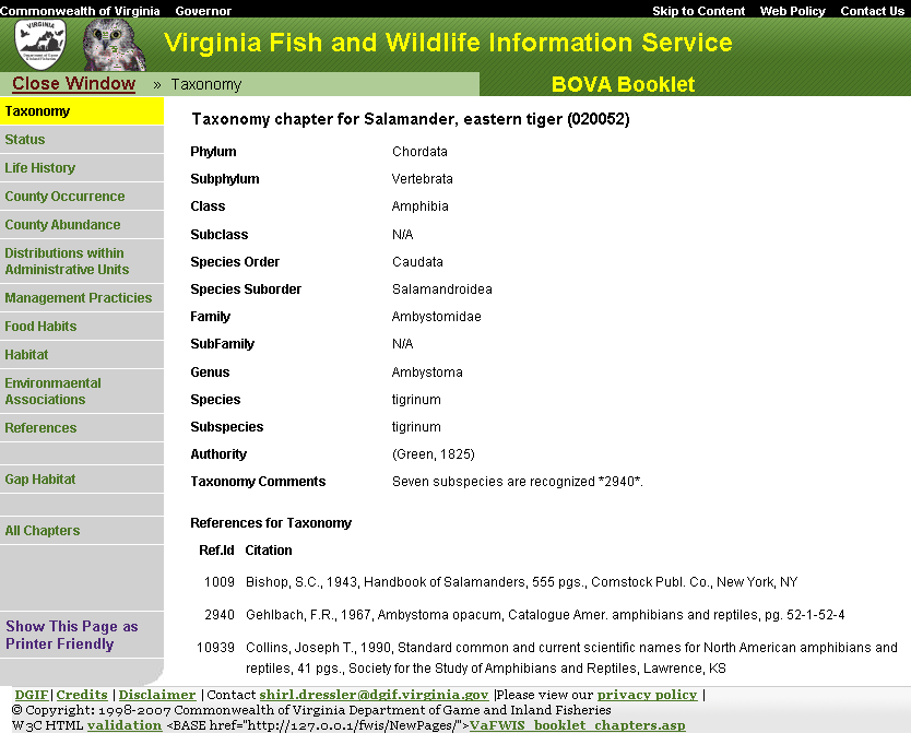
In my own web site, may I include a link to a BOVA species booklet?
Yes, but this method may change without notice:
First you need to determine the code number for your species of interest.
As an example, 050049 can be found as the Species Code for red fox (Vulpes vulpes fulva)
by using "Species Information By Name", searching "fox",
and finding the row where common name is "Fox, red".
Construct your URL as
Why use the Virginia Fish and Wildlife Information Service (VaFWIS)?
VaFWIS is designed to meet needs of DWR's Environmental Services Section to formulate initial impact assessments
on wildlife resources for project sites.
Planners can perform preliminary site assessments to discover potential occurrence of wildlife
for which DWR requires that project activities meet regulatory requirements.
VaFWIS is used to provide information about Virginia's wildlife to educators,
other state agencies, Federal agencies, landowners, wildlife enthusiasts, school children, non-profit groups,
private industry, private engineering and private consulting firms.
Information in VaFWIS includes
species' distributions across Virginia,
inland waters where DWR may regulate certain activities,
areas of predicted habitat for some species,
and other geographical information about the Commonwealth.
There are over twenty databases and map sources used by VaFWIS
to provide users with current information about Virginia's fish and wildlife.
Why does the Virginia Department of Wildlife Resources (VDWR) manage this system?
The VDWR is mandated to protect Virginia's wildlife.
One of the ways we have chosen to do that is by making information about these species
available to those who need it through VaFWIS.
What is the definition of "wildlife"?
The Code of Virginia states that wildlife includes any species in the animal kingdom.
So, this means that the VDWR has jurisdiction over fish,
birds, mammals, reptiles, amphibians, mollusks, other terrestrial and aquatic invertebrates.
VDWR has jurisdiction over all insects
except those listed as threatened, endangered or candidate.
Who protects threatened, endangered and candidate listed insects?
Are plant and insect data available through VaFWIS?
Data regarding insects that are not designated threatened, endangered, or candidate are maintained by DWR.
Any Data available in VaFWIS concerning insects that are designated threatened, endangered, or candidate
and any plant data
originate from the VDACS or VDCR and are restricted for use in VaFWIS to DWR agency biologists.
Please contact
VDACS
and DCR .
Are there species booklets for plants and threatened and endangered insect species?
Some T&E insects; No plants.
What are the differences between the access levels?
Visitor: These users have limited access to the data.
They are able to view species information and perform geographic searches and map identified resources,
but are not able to view species locations on a map or perform database queries.
When performing searches, they are limited within a 3-10 mile search radius.
These users do not log in to the system.
Login access is restricted to VDWR Clients
designated by the Deputy Director of Statewide Resources, Bureau of Wildlife Resources.
Institution: These users have much greater access to the data.
They are able to access species information, perform geographic searches,
and perform database queries.
When performing geographic searches, these users are limited within a 2-15 mile search radius,
they see buffered (800 meter, offset) threatened and endangered species locations,
and they cannot view species comments located in observation records.
Institution clients cannot view data provided by the Department of Conservation and Recreation.
Biologist: These users have high access to the data.
They are able to perform every VaFWIS search function and view all records
except those data provided by the Department of Conservation and Recreation.
They are able to see exact species location information and perform more specific queries.
PBRWind: These users register for access
relevant to small wind energy projects under "Permit By Rule" restrictions
coordinated with the Commonwealth of Virginia Department of Environmental Quality (DEQ).
When performing small wind energy project searches, they have high access to the data.
They are able to perform VaFWIS Geographic Search functions and view all records
except those data provided by the Department of Conservation and Recreation.
DWR Biologist: These users have the highest access to the data.
They are able to perform every VaFWIS data search function and view all records.
They are able to see exact species location information and perform more specific queries.
This access level is used by Virginia Department of Wildlife Resources biologists.
Administrator: These users have the highest access to the data.
Administrators are able to perform every VaFWIS data search function and view all records.
Administrators are able to see exact species location information and perform more specific queries.
Administrators are able to register logins and see reports concerning the use of VaFWIS.
Administrators are able to initiate editing of BOVA Booklets.
Where do the data come from?
There are multiple sources for the data associated with VaFWIS.
Some databases are from internal sources such as the Scientific Collections database
and the Anadromous Fish Use Areas.
Bald Eagle Nest data is provided with cooperation between DWR and the Center for Conservation Biology.
Whereas others such as the USGS Geographic Names and topographic maps
are subsets of data collected and compiled nationally.
The information contained in the Biota of Virginia (BOVA) booklets for each species
is compiled from numerous literary references.
References for each chapter are listed at the end of the chapter.
For specific information about each database,
please refer to the "database descriptions" located in the Appendix of the user manual located in
the "Help" section and under "Data Descriptions and Metadata".
Biota of Virginia (BOVA) - Aquatic and Terrestrial biologists, Fish and Wildlife Information Services Section, Statewide Resources, Bureau of Wildlife Resources, DWR
Species Observations ( SppObs, Colonial Waterbirds, Bald Eagle Nests ) - GIS group, Fish and Wildlife Information Services Section, Statewide Resources, Bureau of Wildlife Resources, DWR
Bat Colonies - Terrestrial biologist and GIS group, Fish and Wildlife Information Services Section, Statewide Resources, Bureau of Wildlife Resources, DWR
Anadromous Fish Use Streams - Aquatic biologist and GIS group, Fish and Wildlife Information Services Section, Statewide Resources, Bureau of Wildlife Resources, DWR
Impediments to Anadromous Fish Streams - Aquatic biologist and GIS group, Fish and Wildlife Information Services Section, Statewide Resources, Bureau of Wildlife Resources, DWR
Trout Streams - Aquatic biologist and GIS group, Fish and Wildlife Information Services Section, Statewide Resources, Bureau of Wildlife Resources, DWR
Threatened and Endangered Species Waters - Aquatic biologist and GIS group, Fish and Wildlife Information Services Section, Statewide Resources, Bureau of Wildlife Resources, DWR
Bald Eagle Concentration Areas and Roosts - Terrestrial biologist and GIS group, Fish and Wildlife Information Services Section, Statewide Resources, Bureau of Wildlife Resources, DWR
Predicted Habitat for Aquatic species Tier I & II - Aquatic biologist and GIS group, Fish and Wildlife Information Services Section, Statewide Resources, Bureau of Wildlife Resources, DWR
Predicted Habitat for Terrestrial species Tier I & II - Terrestrial biologist and GIS group, Fish and Wildlife Information Services Section, Statewide Resources, Bureau of Wildlife Resources, DWR
Breeding Bird Atlas (Virginia Society of Ornithology-BBA) - GIS group, Fish and Wildlife Information Services Section, Statewide Resources, Bureau of Wildlife Resources, DWR
Dept. Conservation and Recreation Natural Heritage (DCRNH) - Va. Dept. Conservation and Recreation, Natural Heritage Information Manager
Public Land Holdings - Virginia Geographic Information Network
Watersheds - U.S. Geologic Survey
Geographic Names - U.S. Geologic Survey
Road Center Line - Va. Dept. Transportation
Topographic maps - U.S. Geologic Survey - http://terraserver-usa.com
Topographic maps - TOPO! National Geographic
Topographic Index map - U.S. Geologic Survey
River Reach map - U.S. Geologic Survey
Aerial Photography - Virginia Geographic Information Network
HydroUnit Map - GIS group, Fish and Wildlife Information Services Section, Statewide Resources, Bureau of Wildlife Resources, DWR
HydroDrain Map - GIS group, Fish and Wildlife Information Services Section, Statewide Resources, Bureau of Wildlife Resources, DWR
GAP habitat map - U.S. Fish and Wildlife Service, Conservation Management Institute at Virginia Tech, and VaFWIS, Fish and Wildlife Information Services Section, Statewide Resources, Bureau of Wildlife Resources, DWR
BBS (North American Breeding Bird Survey) is no longer available on VaFWIS but may be found at
http://www.pwrc.usgs.gov/bbs.
The Scientific Collections and BOVA databases are updated monthly.
Staff at VDWR is continuously entering collections records
and updating the information contained in the species booklets.
The other databases, such as Threatened and Endangered Species Waters, are updated as new data are made available.
Some of the surveys are performed annually,
others bi-annually, and so on.
Data from these surveys are therefore made available at different times and rates during the year.
VDWR keeps the data as current as possible.
Who do I contact if I get a "hit" in my project area for a threatened or endangered species?
For wildlife species including invertebrates, you need to contact VDWR's Environmental Services Section, at 804-367-6913.
For insects, you need to contact VDACS's Plant Protection Biologist, Keith Tignor at 804-786-3515.
How do I get a copy of the user manual and appendix?
Documents are available online through VaFWIS from the "help" link
in the navigation menu on the left side of the screen.
There is a link "All VaFWIS Help Pages Combined" that is the current "manual".
An appendix "Database Descriptions and Field Definitions" is provided in .PDF format for easy downloading and printing.
How often is the manual updated?
Changes and enhancements will continue to be made to VaFWIS as new GIS layers and data sets become available.
Help pages are updated when changes are made to the system and when clients suggest or provide enhancements.
What web browsers are supported?
This website requires your browser to have JavaScript enabled.
This website does not require your browser to accept cookies for "Visitor" access.
This website requires your browser to accept cookies from this website for "Login" privileged access.
This website can be viewed using the latest version browsers:
Chrome from Google
Firefox from Mozilla
Internet Explorer* from Microsoft
Opera from Opera Software
Safari from Apple
* - mapping (JavaScript) functions perform slowly in IE browsers, IE version 8 is better than 7 or 6.
What do I do if I have comments, my login doesn't work, I want to get a login or have questions about the data?
Overview:
You may request a list of Bald Eagle nest sites, concentration areas, and roosts
occuring within 3 miles of some location that you can identify by pointing on a map.
Maps and reports specific to Bald Eagle are presented
using this Bald Eagle Search Map
(
http://vafwis.org/fwis/BaldEagleSearchMap.html)
to access the Virginia Fish and Wildlife Information Service (VaFWIS).
Bald Eagle information is just one component of VaFWIS Geographic Search.
Please use VaFWIS
(
http://vafwis.org/fwis/)
Geographic Search to view additional information
about Virginia wildlife resources in your area.
Begin by defining your search area:
point the mouse at a place on the map of Virginia near a location of interest to you.
Click the mouse while pointing to chosen location and your selected map area will show in a pop-up window
as a more detailed map having center at the point you clicked.
Using your mouse and controls available on the map window you can change the base map,
pan the map North, South, East or West,
and zoom in or out until you establish the point you want.
Clicking the "Submit" button on the map pop-up window will close the pop-up window
and transfer the current map location to the Bald Eagle Search Map page.
Clicking the "Cancel" button will close the map pop-up window
with no change in location.
A search distance of 3 miles from the "Currently selected point" will be used.
The "Currently selected point" coordinates is an "Input" control that
you may enter North American Datum 1983 coordinates
as from a GPS display rather than pointing at the map.
Click "Report" button and a new Bald Eagle report page
is displayed with:
Bald Eagle nest sites
Bald Eagle concentration areas and roosts
Links to view maps that emphisize specific sites
Menu items invoking VaFWIS multi-species search functions
Browser Issues as of May 2011
Microsoft IE 8 - no known issues ( meta tag sets Emulate IE7 mode )
Mozilla Firefox 3+ - no known issues
Opera 9+ - no known issues
Apple Safari 4 - cursor style not changed; position off 2x2 pixels
Google Chrome 11 - cursor style not changed; position off 2x2 pixels
Microsoft IE 6 - change text size - map not resized; position is calculated correctly
Microsoft IE 7 - zoom - map position not correctly calculated
when browser set for zoom in or zoom out ( set browser zoom at 100% )
Introduction to the Fish and Wildlife Information Service
Species Information and Species Lists
September 2009
Overview
Reviews of fish and wildlife literature for all native and
naturalized species of Virginia are performed by Department of Wildlife Resources biologists and through contracts with universities and
specialists.
Their efforts are summarized
and indexed in
an agency database called Biota of Virginia (BOVA). Information is
organized for each indexed species into a collection of reports called
a BOVA Booklet. Initial
support for
developing BOVA was provided by the Office of Surface Mining, the
Bureau of Land Management and Virginia Polytechnic Institute and State
University. Development of BOVA followed "A Procedure for Describing
Fish and Wildlife" developed with the U.S. Fish and Wildlife Service's
Eastern Energy and Land Use Team. Extensive literature exists for some
species, but for many species there is little to no published
information. BOVA represents the best effort to summarize all available
information concerning Virginia's fish and wildlife. There is
continuous effort made to ensure BOVA contains accurate and most
complete information
available. Inclusion or exclusion of any
particular species from a list is based on information summarized from
books, journals, and scientific reports made available to VDWR
biologists. BOVA booklets may be viewed using links associated with any
report that includes a list of species.
Literature used in BOVA
can be searched using Species Information References.
Get a List of Species
Two forms, Species Information By Name and
Species Information By Land Management
allow you to view lists of fish and wildlife
species, each with a link to a BOVA
booklet. You can also get a list of species
using Geographic Search.
Species Information By Name
Use Species Information By Name when you know:
part of a common name or a Latin scientific name such as "salamander"
or "ambystoma".
name of an administrative unit
name for a City or County such as "Wise" or "Richmond".
name of a U.S.G.S. 7.5' quadrangle such as "Burnsville".
name of a hydrologic unit such as "UPPER SOUTH FORK SHENANDOAH RIVER".
species category name such as "birds".
Conservation Concern name such as "Endangered".
a combination of the above to refine a list.
none of the above to get a list of over 3200 species recorded in BOVA.
Species Information
By Land Management
Use Species Information By Land Management when exploring:
Land Use or Land Cover category
Adverse management practices
Beneficial management practices
Existing management practices
refine your search by species category name such as
"birds".
a combination of the above to refine a list.
^
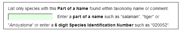
Help with County, Quadrangle, or Hydrologic Unit Selection
Help for VaFWIS Unit Search
Vafwis Unit Search identifies a county, quadrangle, or hydrologic unit
to narrow scope in a data search.
Click the radio button to designate which unit name list is to be presented.
A page with available names and a map will pop-up.
Then you may select one unit name by:
Clicking within mapped unit boundary
Mouse Hover highlights the unit and displays its name
Mouse click selects the unit name
typing a unit name
The list of names is reduced as you type to include only those matching letters.
Clicking a unit name within the provided list.
The unit name is selected.
Button "Clear" will remove any selection and restore the complete list.
Button "Use Selected" will fill the originating form with your selection.
Example County Unit map with mouse pointer hover over Craig County.
Example County Unit selection after mouse click over Wythe County.
Example County unit name list when typeing "be"
example County unit selection when clicking on "Bedford" in the unit name list.
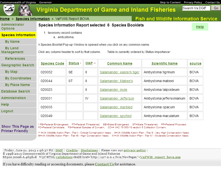
Help using Species Information By Name to get a list of species.
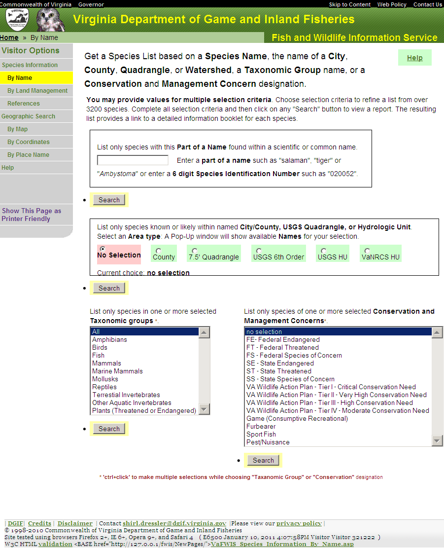
Supply a value for any or all selection criteria:
part of a common name or a Latin scientific name or a word found in taxonomy comments, such as "frog" or "ambystoma".
select a subset area of the state
name for a City or County such as "Wise" or "Richmond".
City/County matches BOVA Booklet County Occurrence and,
for Tier I & II species,
matches counties based on 6th order hydrologic unit species association.
name of a U.S.G.S. 7.5' quadrangle such as "Burnsville".
name of a hydrologic unit such as "UPPER SOUTH FORK SHENANDOAH RIVER".
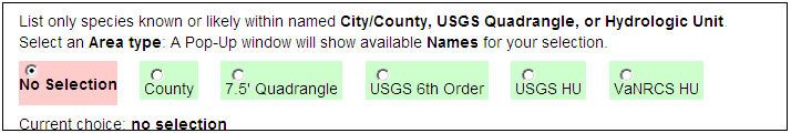
Species Taxonomic Category name such as "birds".
Conservation Concern name such as "Endangered".
You may select multiple entries for Species Category and also for Conservation Concern.
After selecting criteria click any "Search" button to submit your request to display the resulting species list.
Clicking "Search" with no criteria selected will result in a list of over 3200 species.
To get a list of species associated near the name of a place on a map, use instead: Geographic Search By Place Name
VaFWIS Species Information "Name" search options
Searching "By Name" is designed to select a list of species using minimum input.
As such, the intent is not to select an individual species using search criteria,
but to provide a list.
Rather than have complicated search critera options presented as a form for you to complete,
criteria are assembled based on content and style of a single line request.
It is easy to get a short list that includes the individual species desired,
but you may not be able to refine your criteria to get only the exact list you desire.
Species lists may be reliably selected using BOVA Species Codes or ITIS TSN numbers;
but using those numbers is not a normal approach.
Species code
a 6 digit BOVA Species Code number; include a leading zero as appropriate.
an ITIS (Integrated Taxonomic Information System) TSN (Taxonomic Serial Number) species number
begins "tsn" with appended TSN number such as "tsn80070"
examples
"080070" returns one species
"080070,tsn80070" returns two species
"080070,80070" returns one species
because "80070" does not match BOVA or TSN pattern;
therefore, it must match other content,
but in this case it does not.
Taxa Group
a "complete" (includeing spaces) Taxa Group Name from the following
Fish
Amphibians
Reptiles
Birds
Mammals
Aquatic Molluscs
Aquatic Crustaceans
Aquatic Insects
Other Aquatic Invertebrate Taxa
Terrestrial Insects
Marine Mammals
a Taxa Group Code number from the following
1 - Fish
2 - Amphibians
3 - Reptiles
4 - Birds
5 - Mammals
6 - Aquatic Molluscs
7 - Aquatic Crustaceans
8 - Aquatic Insects
9 - Other Aquatic Invertebrate Taxa
10 - Terrestrial Insects
11 - Marine Mammals
match a string of characters
a string is found to begin one of the following scientific name components
Family
subfamily
Genus
Species
Subspecies
string equal to one of the following scientific name components
Phylum
Subphylum
Class
Subclass
Order
suborder
string contained in
Common Name
string is a complete word in
Taxonomy Comments
Authority
match multiple words
words are space delimited
all words are found within one column
columns searched
Common Name
Taxonomy Comments
Authority
words in a column are determined by spaces and punctuation
a comma separated list of above
a list of species is constructed by adding any species found for each search item
Refining The Search
Additional criteria classes
( administrative units, Taxanomic Group, Management Concern )
refine the search so that each species returned matches at least one selectcion in every criteria class.
^
Help using Species Information By Land Management
Help using Species Information By Land Management to get a list of species based on Land Use or Management Practices.
Supply a value for any or all selection criteria:
Species Taxonomic Category name such as "birds".
Land Use (Land Cover) such as "60:Wetland"
Adverse Management Practices such as "306:Draining wetlands, marshes, ponds, lakes"
Beneficial Management Practices such as "118:Developing/maintaining water holes, ponds, potholes, etc."
Existing Management Practices such as "008:Restricting/regulating human use of habitats"
You may select multiple entries for any of these criteria.
After selecting criteria click any "Search" button to submit your request to display the resulting species list.
Clicking "Search" with no criteria selected will result in a list of over 3200 species.
Reviews of fish and wildlife literature are performed by Department of Game and Inland Fisheries
biologists and their efforts summarized and indexed in an agency database called Biota of Virginia (BOVA).
You may search over 11000 Citations for literature used in the compilation of BOVA.
Enter a key word in the space provided and then click the "Search" button to display a citation list.
Overview:
You may request a list of species known or likely to occur near some location that you can identify
by pointing on a map,
or by entering coordinates such as available from a Global Positioning Satalite receiver,
or by entering part of a name that can be found published on a U.S.G.S topographic map.
Reviews of fish and wildlife literature are performed by Department of Wildlife Resources
biologists and their efforts summarized and indexed in an agency database called Biota of Virginia (BOVA).
Extensive literature exists for some species, but for many species there is little to no published information.
BOVA represents the best effort to summarize all available information concerning Virginia's fish and wildlife.
There is continuous effort made to ensure BOVA contains accurate and most complete information available.
Inclusion or exclusion of any particualr species from a list
is based on information summarized from books, juornals, and scientific reports made available to DWR biologists.
A species list resulting from a Geographic Search is based on
references for distribution of species in Virginia
by City and County,
by United States Geologic Survey 7.5 minute quadrange,
by United States Geologic Survey Hydrologic Unit (watersheds),
and by United States Department of Agriculture Natural Resources Conservation Service Hydrologuc Unit (watersheds).
The point of interest and search radius you provide determin which will be used.
Pick a point of interest in Virginia and specify a radius around this point there by defining a search area.
There are three ways to determine your point of interest:
By Map:
Use a map of Virginia and your mouse to make a point of interest selection.
Enter a search radius.
By Coordinate:
Enter a Latitude/Longitude or UTM coordinate to make your selection.
Enter a search radius.
By Place Name
Use the USGS Geographic Place Names Database to make your point of interest selection.
Enter a search radius.
Click "Report" button for a list of species known or likely to occur in your search area.
Additional lists in the report include streams having sensitive aquatic species,
streams used by anadromous fish, and a list of streams important to trout.
Also a report concerning the
Virginia Terrestrial GAP project describes your area based on the point of interest and the search radius.
Overview:
You may request a list of species known or likely to occur near some location that you can identify
by pointing on a map.
If you know coordinates such as available from a Global Positioning Satellite receiver,
then you may want to use Geographic Search By Coordinates.
If you know part of a name that can be found published on a U.S.G.S topographic map,
then you may want to use Geographic Search By Place Name.
A species list resulting from a Geographic Search is based on
references for distribution of species in Virginia
by City and County,
by United States Geologic Survey 7.5 minute quadrangle,
by United States Geologic Survey Hydrologic Unit (watersheds),
and by United States Department of Agriculture Natural Resources Conservation Service Hydrologic Unit (watersheds).
The point of interest and search radius you provide determine which will be used.
Begin by defining your search area:
point the mouse at a place on the map of Virginia near a location of interest to you.
Click the mouse while pointing to chosen location and your selected map area will show in a pop-up window
as a more detailed map having center at the point you clicked.
Using your mouse and controls available on the map window you can change the base map,
pan the map North, South, East or West,
and zoom in or out until you establish the point you want.
Clicking the "Submit" button on the map pop-up window will close the pop-up window
and transfer the current map location to the Geographic Search By Map page.
Clicking the "Cancel" button will close the map pop-up window with no change in location.
The "Currently selected point" coordinates is an "Input" control. You may enter North American Datum 1983 coordinates as in Geographic Search by Coordinates.
Change the "Search Radius" entry if you desire.
The area to be searched is defined with the location you choose at the center
and including an area "Search Radius" distant from your chosen location.
Click "Report" button and a new page is displayed with:
species known or likely to occur in your search area
streams in your search area having sensitive aquatic species
Help using Geographic Search BY Coordinates ( October 20, 2011 )
Overview:
You may request a list of species known or likely to occur near some location that you can identify
as coordinates such as available from a Global Positioning Satellite receiver.
If you know part of a name that can be found published on a U.S.G.S topographic map,
then you may want to use Geographic Search By Place Name.
If you do not have a coordinate or name
then may want to use Geographic Search By Map.
A species list resulting from a Geographic Search is based on
references for distribution of species in Virginia
by City and County,
by United States Geologic Survey 7.5 minute quadrangle,
by United States Geologic Survey Hydrologic Unit (watersheds),
and by United States Department of Agriculture Natural Resources Conservation Service Hydrologic Unit (watersheds).
The point of interest and search radius you provide determine which will be used.
Change the "Search Distance" entry if you desire.
The area to be searched is defined as the location you specify expanded
by a "buffer" zone of "Search distance" miles.
Values may range from 3 to 15 miles.
Define your search area:
Enter coordinates for a location of interest to you
following one of the accepted formats shown in the
example.
For UTM coordinates, select appropriate North American Datum and UTM Zone values.
You may click "Show Map" for a pop-up window displaying your coordinates
in the center of a detailed map.
If your coordinates are UTM then you can verify the datum and zone selection.
Using your mouse and controls available on the map window you can change the base map,
pan the map North, South, East or West,
and zoom in or out until you establish the coordinate you want.
Clicking the "Submit" button on the map pop-up window will close the pop-up window
and transfer the current map location to the Geographic Search By Coordinates form.
Clicking the "Cancel" button will close the map pop-up window
with no change to the form.
Click "Report" button and a new page is displayed with:
species known or likely to occur in your search area
streams in your search area having sensitive aquatic species
streams in your area used by anadromous fish
streams in your area important to trout.
Bald Eagle Concentration Areas and Roosts.
Habitat Predicted for Aquatic
Department of Game and Inland Fisheries Wildlife Action Plan Tier I & II Species.
Habitat Predicted for Terrestrial
Department of Game and Inland Fisheries Wildlife Action Plan Tier I & II Species.
Virginia Society of Ornithology Breeding Bird Atlas Blocks.
USFWS Breeding Bird Survey Routes.
Audubon Society Christmas Bird Count Survey.
Lists of Public Lands and watersheds
Near Place Names from USGS Geographic Names Information System
Example coordinates
*
Example coordinate formats all representing the same point:
Latitude and longitude
Note: both negative and unsigned longitude
are West hemisphere.
37,05,09 77,38,11
Degrees, Minutes, and Seconds
37,05,09 -77,38,11
Degrees, Minutes, and Seconds
370509 773811
Degrees, Minutes, and Seconds
37,05.1500 77,38.1833
Degrees, Decimal Minutes
37.085833 77.636333
Decimal Degrees
UTM East, North, Zone NAD 1927
265661 4107443 18
meters zone 18
799004 4109487 17
meters zone 17
799004 4109487
meters (default zone 17)
Note: a "complete" coordinate is made up of all parts needed
to identify a point on a map.
Latitude may be one decimal value or contain parts for degree, minute, and second.
When Latitude is made up of parts then the parts need to be combined by comma (,) and presented using no spaces.
Longitude is presented in the same manner as Latitude.
When Latitude is provided then Longitude follows after a space on the same line.
When UTM East is provided then UTM North and optionally Zone follow on the same line separated by space.
A Tab character may be used in place of a space character.
UTM Coordinate Creep
Because typical VaFWIS reports represent landscape searches over thousands of meters,
while using VaFWIS the
DWR staff are not concerned about UTM coordinate precision within plus or minus 10 meters.
Coordinates are represented as Latitude / Longitude within VaFWIS program modules.
When a client chooses to display coordinates as UTM (Universal Transverse Mercator),
values entered by the client will be converted to Latitude / Longitude within a precision of about 1 meter.
Internal Latitude / Longitude values may be converted back to UTM for display with a precision of about 1 meter.
Coordinate values may change slightly with each conversion.
Converting UTM to Latitude / Longitude, and then converting that result back to UTM
will likely result in a value within 2 meters of the original.
The accumulated change in value is called "Coordiante Creep".
Help using Geographic Search BY Place Name(May 10, 2011)
Overview:
You may request a list of species known or likely to occur near some location that you can identify
a part of a name that can be found published on a U.S.G.S topographic map.
( names table download available from USGS Geographic Names Information System at
http://geonames.usgs.gov/domestic/download_data.htm)
Virginia road names and route numbers provided by the
Virginia Geographic Information Network
are also available as an option.
If you know a coordinate such as available from a Global Positioning Satellite receiver,
then you may want to use Geographic Search By Coordinates.
If you do not have a name or coordinate
then may want to use Geographic Search By Map.
A species list resulting from a Geographic Search is based on
references for distribution of species in Virginia
by City and County,
by United States Geologic Survey 7.5 minute quadrangle,
by United States Geologic Survey Hydrologic Unit (watersheds),
and by United States Department of Agriculture Natural Resources Conservation Service Hydrologic Unit (watersheds).
The point of interest and search radius you provide determine which will be used.
5 Steps to obtain a Geographic Search By Name
Step 1 - enter part of a name:
Enter a part of a name likely to be found on a map.
Select the appropriate "Beginning", "Ending", or "Contains" option for your name part search.
Decide whether or not to add road names and route numbers provided VGIN.
click the "Name Search" button to have your page updated with a table of places matching your name part.
Step 2 - select a name from a list:
Select a name from the list provided using Step 1.
Selection is performed by clicking on the radio button, the place name, or "View Map"
Click any "View Map" for a pop-up window displaying that choice
in the center of a detailed map.
Your "Point of Interest" is displayed in the center of the map.
Using map controls you may change the center display point,
and the "Point of Interest", by clicking on another map point.
You may click the map control "Submit" button to have a new "Point of Interest"
returned to the Geographic Search by Name page and close the map window.
Clicking the map control "Submit" button signals the Geographic By Name page to
display a new informational section of names "near" your "Point of Interest".
You may close the map window by clicking the "Cancel" button.
You may display the table of place names sorted by a column: click on the column heading.
If you can not find the name you want then please modify your Step 1 entry and try again.
Step 3 - Enter a Search Distance
Search distance is in miles from your "Point of Interest".
The area to be searched is centered over your point
and includes the area within "Search Distance" distant from your chosen location.
Step 4 - Please verify your "Point of Interest".
It is easy to get a correct report for a wrong location.
Click the "Show Map" button
to the see a map centered at the point for which the report will be generated.
Step 5 - Display Report
Click "Report" button and a new page is displayed with:
species known or likely to occur in your search area
streams in your search area having sensitive aquatic species
Help with Search Report (last updated: October 12, 2012)
Overview:
The Project Review Report summarizes the threatened and endangered species,
managed trout streams, anadromous fish use areas,
Bald Eagle concentration areas, colonial waterbird colonies,
threatened and endangered species waters,
and state lands occurring within the search area.
Parts to this report:
Threatened and endangered species occurrences
- a list of any threatened, endangered, special concern or candidate species known or likely
to occur within your search area.
This section will include records from the Biota of Virginia (BOVA) database,
Breeding Bird Atlas (BBA), Bald Eagle concentration zones, roosts, and nests (BECAR,BAEANests),
the Species Observation (scientific collections and surveys) database, and
Colonial Waterbirds (CWB).
Information contained in this section includes the following columns:
BOVA (Biota of Virginia) Code: 6 digit code for each species in Virginia
Status: any special status the species may have.
By default, the report is sorted so that the species with the highest status level
is promoted to the top of the list.
Definitions for these are located below the table.
Common Name: the common name that is recognized for this species in Virginia.
This is a link to the Species Information Booklet.
Scientific Name: the latin name that is recognized for this species.
Anadromous Fish Use Reaches
- this section lists any stream or river reach confirmed to be or potentially to be used by anadromous fish
during the spawning season.
This section includes:
Stream ID: distinct identifier for this reach.
The ID is a link to record details.
Stream Name: name (if known) of the reach
Reach Status: status of the reach (confirmed or potential)
View map: a link to a map of the reach location
Impediments to Fish Passage.
- this section lists dams and other impediments to fish movement.
This section includes:
ID: distinct identifier for this impediment.
Name: name (if known) of the structure.
The Name is a link to record details.
River: name of river impeded.
View map: a link to a map of the reach location
Threatened and Endangered (T&E) Species Waters
- this section lists any T&E species waters known to occur within your search area.
This section includes:
Reach ID: unique identifier for this survey. This is a link to record details.
Stream Name: name (if known) of the water.
Designation: designation of the water (F = federal F/S = federal and state).
View map - a link to a map of the reach location.
Managed Trout Streams
- this section lists any managed trout streams known to occur within your search area.
This section includes:
Reach ID: unique identifier for the reach. This is a link to the record details.
Stream Name: the name (if known) of the reach.
Class: designation as either a wild trout water (Classes I-IV) or a stockable trout water (Classes V-VI).
Brook Trout: a "Yes" in this column means that brook trout has been confirmed in this stream.
Brown Trout: a "Yes" in this column means that brown trout has been confirmed in this stream.
Rainbow Trout: a "Yes" in this column means that rainbow trout has been confirmed in this stream.
View Map: this is a link to view the trout stream location on a map.
Bald Eagle Concentration Areas and Roosts
- this section lists areas identified as important to Bald Eagle.
This section includes:
View Map: this is a link to view the trout stream location on a map.
BECCAR ID: unique identifier
Authority: Observer or institution responsible for this record.
Type: use description
Comments: provided by the authority on this record
Habitat Predicted for Aquatic WAP Tier I & II Species
- this section lists any waters
that occur within your search area
predicted to contain habitat suitable for select Tier I & II aquatic species.
This section includes:
Reach ID: unique identifier for this survey. This is a link to record details.
Stream Name: name (if known) of the water.
Designation: designation of the water (F = federal F/S = federal and state).
View map - a link to a map of the potential habiat reach location.
Habitat Predicted for Terrestrial WAP Tier I & II Species
- this section lists species
that may occur within your search area based on
prediction for habitat suitable and within normal occurrence range for select Tier I & II terrestrial species.
This section includes:
BOVA Code: unique identifier for this species.
Status: Federal and State Theatened and Endangered status.
Tier: DWR Wildlife Action Plan Tier designation.
Common Name: Common name for this species. This is a link to BOVA Booklet details.
Scientific Name: Scientific name for this species.
View map - a link to a map that highlights predicted habitat for selected species.
Breeding Bird Atlas Survey
- this section lists bird surveys of breeding birds submitted by the Virginia Society of Ornitology.
This section includes:
Survey ID: unique identifier for the survey location. This is a link to the record details.
Atlas Quadrangle Block Name:name of the quadrangle and block surveyed.
View Map: a link to view the block on a map.
Quadrangles - list of U.S.G.S 7.5' quadrangle names associated with your search area.
Watersheds - list of watershed names associated with your search area.
Public Lands - list of public land holdings associated with your search area.
Overview:
This window allows you to measure distances or change the type, scale and size of the map you
are viewing. You may add coverage layers, remove location rings, change the base
layer map type, change the map center location, identify features and change the map scale all using this
window. Below is an explanation of how to use the features.
Please note that every time you make a choice, therefore changing some
aspect of the map view, the map will automatically refresh.
Left of Map:
Point of Interest - this refers to the point that you want to perform a
search around.
Submit button - returns coordinates when map page initiated from a form.
Change to clicked map point - as you point and click around the map,
you are changing the area of interest.
Notice that the lat/long values above change as you move around the map.
Fixed at -
this fixes your point of interest to the most recent clicked point.
Notice that after you have chosen this,
the lat/long values remain constant as you move (by clicking) around the map.
Display -
clicking on this button results in the point of interest
being displayed in the center tile of the map on this page.
Show position rings -
allows you to turn on/off the position rings (bull's eye)
around your point which is a default display.
Show Search Area -
allows you to turn on/off shading for your search area when map page initiated from a form.
Base Map -
allows you to decide what type of base map you want to view on
this map. Some choices such as "Topography" may allow you to more easily and
clearly determine your point of interest. The default display is "County". You
can click on the "Choices" link to get a description of each map type or simply
use the drop down menu to make your choice. The map will automatically refresh
once you have made a choice.
Topography - a topographical map. This has roads, water bodies, forests, forested lands, disturbed
areas, and the rise and fall of the land marked on it.
Satellite - these are satellite photographs (Digital Ortho-photo Quarter Quads - DOQQs) of Virginia in black and white.
County - (default) - this is a white map with only the county lines, names and FIPS codes marked on it.
Hydrography - this is a white map with only the watersheds in Virginia outlined, named and coded on it.
TopoIndex - also a topographical map, this one is distributed by the USGS.
White - a white map with only the position rings viewable.
Map Overlay
- allows you to decide which overlays or "layers" you would like to see on the map. In this
case, you have to click on the "choices" link in order to view your options.
Once you check off the layer(s) you desire, click on the "apply" to refresh the
map.
Trout - overlays trout designated trout streams from the Cold Water Stream Survey.
Anadromous - overlays designated anadromous fish use areas.
TE Waters - overlays designated threatened and/or endangered species waters.
Bald Eagle nests, concentration areas, and roosts.
Tier I & II - show Virginia Department of Games and Inland Fisheries Wildlife Action Plan Tier I & II species observations as 2 mile buffers.
Habitat - show predicted habitat for many Virginia Department of Games and Inland Fisheries Wildlife Action Plan Tier I & II species.
Position rings - show rings drawn around the point of interest.
Database Records found in search (only available if these records exist within your search area)
Search area - displays your search area on the map.
SppObs - overlay all species observation records found in your search area.
BBA - overlay all Breeding Bird Atlas records found in your search area.
CWB - overlay all Colonial Water bird Colonies found in your search area.
Observation - overlay selected record identified in a report.
Map Overlay Legend
- located beneath the map overlay option, it describes
features on the map such as search area, collection locations, trout streams.
Identifies each color on the map overlay.
Above the Map:
Virginia Department of Wildlife Resources shield - link to Va. DWR home page.
small image of Virginia boundary - shows location and coverage of current map
Back - link to view previous map
coordinates - shows location of mouse pointer when over the map.
Refresh Browser Page - request a new map page that can be bookmarked.
"Click Map" - Three adjacent buttons direct action of a Mouse click on the map to
a "Pan" action or an "ID" popup window or a "Map Measure Tool".
The current "Click Map" action is indicated by the brightest of these three buttons.
Click on a dim button to disable the current "Click Map action" and enable your choice.
Pan - Change Location Viewed - when activated allows
you to point and click on the map to have a new area shown in the map center.
the center to the point clicked.
ID - Identify Features - when activated allows you to
identify certain features on the map. For example, if you have chosen to look at
a map with multiple collection points on it and then decide you want to
identify one from the other, simply click on the "ID" button and then click on
the feature of interest on the map. A window will pop up that contains the known
attributes for all features at that neighborhood.
M - Map Measure Tool - this feature, when activated by clicking on it, allows you to
measure distance and area. A pop-up window will appear with controls for directing
the measure tool. Choosing "Drag Your Mouse" allows you to hold the left mouse
button while delineating an area.
When in "Drag Your Mouse" mode the "Backup" control will remove the last line.
Choosing "Point Your Mouse" allows you to
point and click precise points to form a line or polygon.
When in "Point Your Mouse" mode the "Backup" control will remove the last point
from the line.
Click on the "Finish" control for a report.
Click twice on the "Finish" control to clear your points and lines.
"Show Coordinates" displays a text area containing coordinate data for your points and lines.
When done with the map measure tool you may close the tool control window, or
click one of the "Pan", "ID", or "M" buttons to resume a "Click Map Action."
Map Scale Zoom - this option
found above the map allows you to zoom in and out on the map. Clicking on the
bars to left zoom you in and clicking on the bars to the right zoom you out.
Screen Size - this option, also found above the map, allows you to
increase or decrease the size of the map on the screen. Clicking on the bars to
the right left decreases the map size and clicking on the bars to the right
increases the map size.
Help - link to this "Help" page.
Below the Map:
Scale Bar - located beneath the map, this changes as the scale of the map
changes. You can use this bar to measure distance on the map.
North arrow - located underneath the map, this displays the direction of
North on the map.
Coordinate System - located underneath the map, this allows you to choose
the system for displaying coordinates.
Map Information - located underneath the map, this information may help
you determine map scale and type, your point of interest coordinates and the map
location (the center tile point).
Printing the map:
VaFWIS Maps Measure Tool uses "background color" to show the drawn line.
Under normal circumstances, to save ink, background-colors are not printed.
Your browser needs to be enabled to print "background colors" in order to print the Map Measure line.
Recommendation: disable printing of background-color when finished printing VaFWIS Maps.
Set Print for Background-Color as of May 2011:
The Virginia Department of Wildlife Resources (VDWR) would like to
thank the Conservation Management Institute
at Virginia Polytechnic Institute and State University
for their cooperation in developing the Virginia Fish and Wildlife Information Service.
Without their expertise and support, this system would not have been possible.
VDWR would also like to thank the following organizations
who provide data, assist in collecting and compiling data,
or setting up procedures used on the Virginia Fish and Wildlife Information Service.
This database is used to query species specific information.
Collections Database
This GIS database locates
wildlife as observed by professional biologists.
Data entry for the Collections database was funded, in part,
by the Virginia Coastal Zone Management Program at the Department of Environmental Quality
through Grant #NAO4NOS4190060 of the U.S. Department of Commerce,
National Oceanic and Atmospheric Administration,
under the Coastal Zone Management Act of 1972, as amended.
Bald Eagle Nests
Center for Conservation Biology, College of William & Mary and Virginia Commonwealth University
Virginia Fish and Wildlife Information Service Use and Access AgreementFebruary 2014
Send original, signed form to:
Virginia Department of Wildlife Resources
Attn: Environmental Services Section
P.O. Box 90778
Henrico, VA 23228-0778
As a condition for registered use of the Virginia Department of Wildlife Resources' (VDWR)
Virginia Fish and Wildlife Information Service (VAFWIS),
I understand and agree to abide by the following terms and qualifications
that govern my access to and use of this system:
VDWR is not responsible for the use and interpretation of data from this service
by individuals outside of the agency.
While the Department strives to ensure that the data are as accurate as possible,
errors can occur.
The Department does not warrant the data as suitable for the use to which they are being acquired.
Questions concerning the use and interpretation of data should be directed to Environmental Services Section of VDWR.
Data obtained from the VAFWIS are provided for information and planning purposes only
and do not constitute an official legal opinion of VDWR.
I understand that the VAFWIS is a dynamic system
and that I am responsible for ensuring that queries are conducted in a timely manner
in relation to my particular needs.
I agree to acknowledge VDWR and the VAFWIS when data from this service are used in reports,
publications, or in any similar manner.
I understand that VDWR agrees to provide documentation and helpdesk support
for the VAFWIS and updates to it as needed.
I agree to fully identify any and all individuals with use of and access to the VAFWIS
using the user-id and password assigned to me.
VDWR retains the right to terminate my access to the VAFWIS
for violations of any of the preceding terms and provisions
or other inappropriate use of the VAFWIS.
By signing this agreement,
I declare that I understand the preceding terms and provisions
and that I accept responsibility of adhering to the same.
____________________________________________
User Signature
____________________________________________
Date
____________________________________________
User Name (Please Print)
 This is the "Home Page" for visitors to the
Virginia Fish and Wildlife Service. Without logging in (unregistered
users), visitors may get lists of species using either "Species
Information" of "Geographic Search" menu items. From each species in a
list you can link to scientific information gathered using library
literature reviews and research observations.
This is the "Home Page" for visitors to the
Virginia Fish and Wildlife Service. Without logging in (unregistered
users), visitors may get lists of species using either "Species
Information" of "Geographic Search" menu items. From each species in a
list you can link to scientific information gathered using library
literature reviews and research observations.
 Their efforts are summarized
and indexed in
an agency database called Biota of Virginia (BOVA). Information is
organized for each indexed species into a collection of reports called
a BOVA Booklet. Initial
support for
developing BOVA was provided by the Office of Surface Mining, the
Bureau of Land Management and Virginia Polytechnic Institute and State
University. Development of BOVA followed "A Procedure for Describing
Fish and Wildlife" developed with the U.S. Fish and Wildlife Service's
Eastern Energy and Land Use Team. Extensive literature exists for some
species, but for many species there is little to no published
information. BOVA represents the best effort to summarize all available
information concerning Virginia's fish and wildlife. There is
continuous effort made to ensure BOVA contains accurate and most
complete information
available. Inclusion or exclusion of any
particular species from a list is based on information summarized from
books, journals, and scientific reports made available to VDWR
biologists. BOVA booklets may be viewed using links associated with any
report that includes a list of species.
Their efforts are summarized
and indexed in
an agency database called Biota of Virginia (BOVA). Information is
organized for each indexed species into a collection of reports called
a BOVA Booklet. Initial
support for
developing BOVA was provided by the Office of Surface Mining, the
Bureau of Land Management and Virginia Polytechnic Institute and State
University. Development of BOVA followed "A Procedure for Describing
Fish and Wildlife" developed with the U.S. Fish and Wildlife Service's
Eastern Energy and Land Use Team. Extensive literature exists for some
species, but for many species there is little to no published
information. BOVA represents the best effort to summarize all available
information concerning Virginia's fish and wildlife. There is
continuous effort made to ensure BOVA contains accurate and most
complete information
available. Inclusion or exclusion of any
particular species from a list is based on information summarized from
books, journals, and scientific reports made available to VDWR
biologists. BOVA booklets may be viewed using links associated with any
report that includes a list of species.
 Literature used in BOVA
can be searched using Species Information References.
Literature used in BOVA
can be searched using Species Information References.


 Center for Conservation Biology, College of William & Mary and Virginia Commonwealth University

 Virginia Commonwealth University Biology Department,


